Langogne France – Francia
- Maria Scuor
- May 20, 2024
- 13 min read
Italiano in ogni sezione

My father left Italy when he was 18 years old to avoid the mandatory military requirements of Italy. He moved to a little town in France called Langogne and worked as a cabinet maker. He married my mom and brought her to Langogne in January of 1963 and I was born in September of that year.
I really wished I would have paid more attention to my parents when they brought us back to Langogne for a visit because I would have loved to remember the house we lived in. But there were a few things that brought back memories and tears, during this visit. Last time I visited was with Gianni, 40 years ago on our honeymoon, therefore things have changed but yet some things have stayed the same.
From Arona we had to go through the Fréjus tunnel which connects Italy and France. It runs under the Col de Fréjus in the Cottian Alps between Bardonecchia in Italy and Modane in France. Construction started in 1974 and opened for transport July 12, 1980. It is 13 km (8.1 mi) long making it the 13th longest tunnel in the world.
Due to a fire in the Mont Blanc tunnel in 1999, safety measures were taken in 2000 to improve tunnel safety for all. Tunnel is equipped with smoke and flame detectors, video cameras to detect speed of traffic which the tunnel has a strict 70km (43 mph) speed limit and a distance of 150 m (160 yd) between vehicles. Temperature sensors, fire hydrants, safety points with telephones as well as a separate ventilation duct to supply fresh air were also added.
With all these measures, two people died due to a fire in the tunnel in 2005. It took two months to repair before opening up for traffic again. Two bores, emergency rescue tunnels were built and at about 4 km of each end of the tunnel sits a team of four intervention firefighting teams.
With these preventions we felt very safe driving through from the Italy to the France side.
Here are photos of us going through the tunnel - Ecco le foto di noi che attraversiamo il tunnel


Mio padre ha lasciato l'Italia quando aveva 18 anni per evitare i requisiti militari obbligatori dell'Italia. Si trasferì in una piccola città della Francia chiamata Langogne e lavorò come ebanista. Sposò mia madre e la portò a Langogne nel gennaio del 1963 e io nacqui nel settembre di quell'anno.
Avrei davvero voluto prestare più attenzione ai miei genitori quando andavamo a trovarli, perché mi sarebbe piaciuto ricordare dove vivevamo. Ma ci sono state alcune cose che mi hanno riportato alla mente ricordi e lacrime, durante questa visita. L'ultima volta che ci sono stato è stato con Gianni, 40 anni fa in viaggio di nozze, quindi le cose sono cambiate ma alcune cose sono rimaste le stesse.
Da Arona dovevamo passare per il tunnel del Fréjus che collega l'Italia e la Francia. Corre sotto il Col de Fréjus nelle Alpi Cozie tra Bardonecchia in Italia e Modane in Francia. La costruzione è iniziata nel 1974 ed è stata aperta al traffico il 12 luglio 1980. È lungo 13 km, il che lo rende il 13° tunnel più lungo del mondo.
A causa di un incendio nel traforo del Monte Bianco nel 1999, nel 2000 sono state adottate misure di sicurezza per migliorare la sicurezza del traforo per tutti. Il tunnel è dotato di rilevatori di fumo e fiamma, telecamere per rilevare la velocità del traffico che il tunnel ha un limite di velocità di 70 km e una distanza di 150 m tra i veicoli. Sono stati aggiunti anche sensori di temperatura, idranti, punti di sicurezza con telefoni e un condotto di ventilazione separato per fornire aria fresca.
Con tutte queste misure, due persone sono morte a causa di un incendio nel tunnel nel 2005. Ci sono voluti due mesi per ripararlo prima di riaprire al traffico. Sono stati costruiti due cunicoli, gallerie di soccorso di emergenza e a circa 4 km da ciascuna estremità del tunnel si trova una squadra di quattro squadre antincendio di intervento.
Con queste prevenzioni ci siamo sentiti molto sicuri guidando dall'Italia alla Francia.
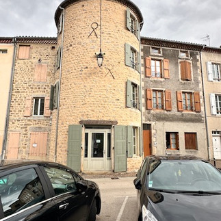
Langone is a commune in the Lozère department of southern France. It is located on the shores of Lake Naussac and has a population of about 3,500 people. The medieval town was founded in 988 by the Benedictine monks of le Monastier and was built around the monastery. It became an important trade centre with its development of its wool and textile industry.
The town was destroyed during the War of Religions in 1568 when 9000 Huguenot French Protestants Troop plundered the city, the church and the monastery. Then during the French Revolution, the fire in the town centre in 1793, destroyed many religious items. However, the town still owns several medieval pieces of architecture (houses, ramparts, etc.).
With the railway station opening in 1860, it direct linked Langonge with Paris and Nimes which led to growth in the meat and tourism industries. Today, the town is renowned for its outdoor activities such as hiking, mountain biking, fishing, sailing, canoeing, and swimming.
Here are photos of sights around town - Ecco foto delle attrazioni della città
Old town - Città vecchia


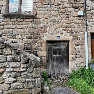


New town - Nuova città


Local art - Arte locale


Langone è un comune francese situato nel dipartimento della Lozère. Si trova sulle rive del lago Naussac e ha una popolazione di circa 3.500 persone. La città medievale fu fondata nel 988 dai monaci benedettini di Le Monastier e fu costruita intorno al monastero. Divenne un importante centro commerciale con lo sviluppo della sua industria laniera e tessile.
La città fu distrutta durante la Guerra delle Religioni nel 1568, quando 9000 protestanti francesi ugonotti saccheggiarono la città, la chiesa e il monastero. Poi, durante la Rivoluzione francese, l'incendio nel centro della città nel 1793 distrusse molti oggetti religiosi. Tuttavia, la città possiede ancora diversi pezzi di architettura medievale (case, bastioni, ecc.).
Con l'apertura della stazione ferroviaria nel 1860, collegava direttamente Langonge con Parigi e Nîmes, il che portò alla crescita dell'industria della carne e del turismo. Oggi, la città è rinomata per le sue attività all'aria aperta come l'escursionismo, la mountain bike, la pesca, la vela, la canoa e il nuoto.
Boulevard Notre Dame
As we climb Boulevard Notre Dame, there is so many old buildings. At the top is the large Convent Chapel and to the left of it is Chapel of Penitents. Two building that held religious orders in the past.
Convent Chapel
Adjoining a building built in 1843 this Convent Chapel used to be a convent for the nuns of the Jeanne de Lestonnac order, this chapel built in the 19th Century has a Romano-Byzantine facade. The 3-meter virgin on the top of the roof was erected on November 21, 1899. The inscription in red letters on a white and gold background can be translated as: “They made me guardian”. This building is now used as a high school.
Chapel of Penitents
Built in 1627, this Chapel welcomed the Estates of Gévaudan in 1721. By the 17th century, the white penitents, a Roman Catholic religious congregation of male brotherhood that was established in Rome in 1264, were a phenomenon typical of southern France and set up in this chapel.
As the number of these confraternities increased, Rome classified them in colours based on the garb they wore during processions and devotional exercises. The garb consisted of heavy white robes confined with a girdle and pointed hood concealing the face with openings for the eyes. The confraternities had their own statues, their own churches and often their own cemeteries. If you wanted to join, you would have had to be on probation for a certain amount of time. The obligation of the shite penitents was to care for the sick, bury the dead, provide medical services for those unable to pay for it, and give dowries to poor girls.
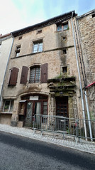
Here are some photos of Boulevard Notre Dame – Ecco foto de Boulevard Notre Dame


Boulevard Notre Dame
Mentre saliamo su Boulevard Notre Dame, ci sono così tanti vecchi edifici. In cima si trova la grande Cappella del Convento e alla sua sinistra si trova la Cappella dei Penitenti. Due edifici che in passato ospitavano ordini religiosi.
Cappella del Convento
Adiacente ad un edificio costruito nel 1843, questa cappella conventuale era un convento per le suore dell'ordine Jeanne de Lestonnac, questa cappella costruita nel XIX secolo ha una facciata romano-bizantina. La vergine di 3 metri sulla sommità del tetto fu eretta il 21 novembre 1899. L'iscrizione in lettere rosse su sfondo bianco e oro può essere tradotta come: "Mi hanno fatto guardiano". Questo edificio è ora utilizzato come scuola superiore.
Cappella dei Penitenti
Costruita nel 1627, questa cappella accolse gli Stati del Gévaudan nel 1721. Nel XVII secolo, i penitenti bianchi, una congregazione religiosa cattolica romana di fratellanza maschile fondata a Roma nel 1264, erano un fenomeno tipico della Francia meridionale e si stabilirono in questa cappella.
Con l'aumentare del numero di queste confraternite, Roma le classificò in colori in base all'abito che indossavano durante le processioni e gli esercizi devozionali. L'abito consisteva in pesanti vesti bianche confinate con una cintura e un cappuccio a punta che nascondeva il viso con aperture per gli occhi. Le confraternite avevano le loro statue, le loro chiese e spesso i loro cimiteri. Se volevi iscriverti, avresti dovuto essere in prova per un certo periodo di tempo. L'obbligo dei penitenti bianchi era quello di curare i malati, seppellire i morti, fornire servizi medici a coloro che non erano in grado di pagarli e dare la dote alle ragazze povere.
Halle – Grain Hall
The Halle or Grain Hall, was built in 1743 by Dom Ambroise Fleury the Prior of the city. This open marvel is located in the city center and has 14 large granite columns, stone paved floor and slate roof. It is the largest preserved building of this type in France.
It was a place where farmers could come exchange their grains, farm products, wool, leather, chestnuts, oils, and wines. Today it is used as a market, crafts and other exhibitions and summer concerts. This building was registered as a historic monument in 1942.
Just in front of the Halle is the Langogne War Memorial which was inaugurated November 12, 1922. It was designed in bronze by famous sculptor Maxime Real Del Sarte. The statue is of a dying soldier wrapped in a French flag and being comforted by Joan of Arc. She is wearing a medieval helmet, a tunic embellished with the fleur de lys and a sword on her side. Her hand is pointing towards the heavens, as she is assuring the dying soldier he will be there soon. The names of the dead of both World War I and World War II are listed on the face of the pedestal.
Here are photos of Halle and the War Memorial – Ecco le foto di Halle e del Monumento ai Caduti


Sala del grano di Halle
La Halle, o Sala del Grano, fu costruita nel 1743 da Dom Ambroise Fleury, il priore della città. Questa meraviglia aperta si trova nel centro della città e ha 14 grandi colonne di granito, pavimento lastricato in pietra e tetto in ardesia. È il più grande edificio conservato di questo tipo in Francia.
Era un luogo dove i contadini potevano venire a scambiare i loro cereali, i prodotti agricoli, la lana, il cuoio, le castagne, gli oli e i vini. Oggi è utilizzato come mercato, artigianato e altre mostre e concerti estivi. Questo edificio è stato registrato come monumento storico nel 1942.
Proprio di fronte alla Halle si trova il Monumento ai Caduti di Langogne, inaugurato il 12 novembre 1922. È stato progettato in bronzo dal famoso scultore Maxime Real Del Sarte. La statua raffigura un soldato morente avvolto in una bandiera francese e confortato da Giovanna d'Arco. Indossa un elmo medievale, una tunica impreziosita dal fleur de lys e una spada al fianco. La sua mano punta verso il cielo, mentre assicura al soldato morente che sarà lì presto. I nomi dei morti della prima e della seconda guerra mondiale sono elencati sulla facciata del piedistallo.
Old Bridge - Ponte Vecchio
Old Bridge - Ponte Vecchi
One thing I remember from when my parents took us to Langogne when I was ten years old was the old bridge. My daddy loved this bridge and I remember him telling me the bridge brought him to the hospital I was born in. Which is just to the left when coming across.
The bridge is now called “Pont Vieux” Old Bridge, but used to be called Peyre Bridge. It crosses the Langouyrou River and is of Roman architecture and construction, but it has been remodelled so many times that it is difficult to determine date of origin. Even though it is old, cars do travel across it all the time.
Here are photos of the road leading to and the Old Bridge - Ecco le foto della strada che porta al Ponte Vecchio


Una cosa che ricordo di quando i miei genitori ci hanno portato a Langogne quando avevo dieci anni era il vecchio ponte. Mio padre amava questo ponte e ricordo che mi disse che il ponte lo aveva portato all'ospedale in cui sono nato. Che si trova appena a sinistra quando ci si imbatte.
Il ponte è ora chiamato "Pont Vieux" Ponte Vecchio, ma un tempo si chiamava Ponte Peyre. Attraversa il fiume Langouyrou ed è di architettura e costruzione romana, ma è stato rimaneggiato così tante volte che è difficile determinarne la data. Anche se è vecchio, le auto lo attraversano continuamente.
Spinning Mill of Calquières Museum - Museo della Filanda di Calquières
The Langouyrou River provided power to several watermills and process water for several tanneries in the past. In the 19th century water-power was used for spinning in the day and grinding grain in the night. In 1828 Pierre-Emmanuel Hippolyte Boyer used the waterwheels to drive looms for weaving. The mill was a small enterprise that employed about ten people. Weaving ceased around 1920 but spinning continued until 1990. One of the mills was purchased by the town in 1992 and the museum opened two years later.
The museum was closed when we were there so we didn’t have a chance to see the inside. I have taken photos from the Lozère Tourism website to show some of the items in the museum.
Here are photos of the Calquières Museum – Ecco foto di Calquières Museum


Il fiume Langouyrou ha fornito energia a diversi mulini ad acqua e acqua di processo per diverse concerie in passato. Nel 19° secolo l'energia idraulica veniva utilizzata per filare di giorno e macinare il grano di notte. Nel 1828 Pierre-Emmanuel Hippolyte Boyer utilizzò le ruote idrauliche per azionare i telai per la tessitura. Il mulino era una piccola impresa che dava lavoro a una decina di persone. La tessitura cessò intorno al 1920, ma la filatura continuò fino al 1990. Uno dei mulini è stato acquistato dal comune nel 1992 e il museo è stato inaugurato due anni dopo.
Il museo era chiuso quando eravamo lì, quindi non abbiamo avuto la possibilità di vedere l'interno. Ho preso delle foto dal sito web della Lozère Tourism per mostrare alcuni degli oggetti del museo.
Church of Saint-Gervais Saint-Protais
This Bourguignon Romanesque style church was built by monks from Saint-Chaffre in the 12th century. Monasteries were flourishing at the time in Gévaudan, a former French province and Viscount Étienne and his wife decided to establish one in Langogne. It is believed Pope Sylvester II gave Langogne the relics of saints Gervais and Protais and why the name.
Side chapels and Gothic portal were added in the 15th century and the church was enlarged in the 19th century as well the bell tower had three bells cast in the 1850 and a fourth in 1900. The nave was also rebuilt. The interior is decorated with paintings, statues and historical motifs. The south chapel houses the Virgin listed as a historic monument, Notre-Dame-de-Tout-Pouvoir which is in the colour black. This church was classified a historic monument in 1840.
Here are photos of Saint Gervais and Protais Church - Ecco le foto della chiesa di Saint Gervais e Protais


Questa chiesa in stile romanico borgognone fu costruita dai monaci di Saint-Chaffre nel XII secolo. I monasteri erano fiorenti a quel tempo nel Gévaudan, un'ex provincia francese, e il visconte Étienne e sua moglie decisero di fondarne uno in Langogne. Si ritiene che papa Silvestro II abbia donato a Langogne le reliquie dei santi Gervais e Protais e perché il nome.
Le cappelle laterali e il portale gotico furono aggiunti nel XV secolo e la chiesa fu ampliata nel XIX secolo, così come il campanile aveva tre campane fuse nel 1850 e una quarta nel 1900. Anche la navata centrale fu ricostruita. L'interno è decorato con dipinti, statue e motivi storici. La cappella sud ospita la Vergine classificata come monumento storico, Notre-Dame-de-Tout-Pouvoir che è di colore nero. Questa chiesa è stata classificata monumento storico nel 1840.
Naussac Lake – Lago Naussac
Naussac Lake is a man-made reservoir generated after the Naussac Dam was built 1980. There had been a project to build the dam since the 1950s. However, it took until 1976 to get approval because it meant moving the whole Naussac village and therefore this caused much controversy. There were many protests while the dam was built because the lake was to support the nuclear power plants and that almost all of the inhabitants of the old village were going to be relocated to the new village of Naussac, rebuilt above the lake and 2 km from Langogne.
With construction finished in 1980, the lake was fully filled by 1982. The dam ensures that during the summer, when it is too hot, it releases water to cool down the Belleville and Dampierre nuclear power plants. It is also used, but at a lesser extent, for local agriculture whenever there is drought.
The Naussac is the largest lake in the Lozère department. It has become a great tourist attraction as it offers many water activities, such as; sailing, windsurfing, kayaking, paddleboard, kitesurfing and the beach area not far from the village of Naussac allows swimming. We drove to the Rougeyre parking lot of Lake Naussac and walked down to the lake to see the incredible red rocks that are naturally formed in this section of the lake. To bad the weather wasn’t nice as they say on a sunny day the reflection of the red rocks on the blue water is spectacular.
Il lago Naussac è un bacino artificiale generato dopo la costruzione della diga di Naussac nel 1980. C'era stato un progetto per costruire la diga fin dagli anni '50. Tuttavia, ci volle fino al 1976 per ottenere l'approvazione perché significava spostare l'intero villaggio di Naussac e quindi questo causò molte polemiche. Ci sono state molte proteste durante la costruzione della diga perché il lago dovevara sostenere le centrali nucleari e che quasi tutti gli abitanti del vecchio villaggio sarebbero stati trasferiti nel nuovo villaggio di Naussac, ricostruito sopra il lago e a 2 km da Langogne.
Here are some photos of Naussac Lake - Ecco le foto del lago Naussac


Con la costruzione terminata nel 1980, il lago è stato completamente riempito nel 1982. La diga fa sì che durante l'estate, quando fa troppo caldo, rilasci acqua per raffreddare le centrali nucleari di Belleville e Dampierre. Viene anche utilizzato, ma in misura minore, per l'agricoltura locale ogni volta che c'è siccità.
Il Naussac è il lago più grande del dipartimento della Lozère. È diventata una grande attrazione turistica in quanto offre molte attività acquatiche, come ad esempio; vela, windsurf, kayak, paddleboard, kitesurf e la zona della spiaggia non lontano dal villaggio di Naussac permette di nuotare. Siamo andati al parcheggio Rougeyre del lago Naussac e siamo scesi al lago per vedere le incredibili rocce rosse che si formano naturalmente in questa sezione del lago. Tristemente il tempo non è stato bello, perché dicono, in una giornata di sole il riflesso delle rocce rosse sull'acqua blu è spettacolare.
Comments